Area of study
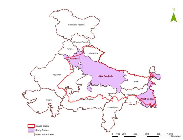
This project focuses on the farming systems of the Ganga River Basin, one of the largest drainage basin areas in the world. The Ganga Basin covers 1,086,000 km2, around one third of the total land area of India, from the Himalayan-Tibetan area in the west to the Bengal Delta in the east. The basin is commonly divided into three zones: the upper Ganga Plain, the middle Ganga Plain and the Lower Ganga Plain. We selected one state in each zone: Haryana (upper plain), Uttar Pradesh (middle plain) and West Bengal (lower plain), along an increasing gradient of rainfall from the western to the eastern part of the basin.
|
District Name
|
Hisar
|
Etawah
|
Bankura
|
|
State Name
|
Haryana
|
Uttar Pradesh
|
West Bengal
|
|
Population (2001)
|
1,536,417
|
1,340,031
|
3,191,822
|
|
Population density (inhab./ km2)
|
386
|
586
|
464
|
|
Total land area (km2)
|
4,072
|
2,212
|
6,936
|
|
Number of blocks
|
4
|
8
|
22
|
|
Climate
|
Tropical steppe
|
Tropical monsoon
|
|
|
Average annual rainfall
|
400-500 mm
|
700-900mm
|
1,400-1,600mm
|
|
Agro ecological characteristic
|
Arid and semi-arid
|
Semi-Arid
|
Sub-humid
|
|
Major livestock
|
Buffaloes, camel, sheep
|
Cows, buffaloes, goats
|
Oxen, goats and sheep
|
|
Major crops grown
|
Cotton, paddy, guar and pearl millet in Kharif*;
Wheat, potatoes, mustard in Rabi*; |
Paddy, pearl millet and vegetables in Kharif; Wheat in Rabi
|
Paddy and vegetables in Kharif; Vegetables in Rabi
|
|
Water sources for cultivation
|
Canal and Tubewell
|
Canal and Tubewell
|
Rainfed and Tubewell
|
|
Major Rivers
|
No Rivers
|
Chambal, Yamuna and Kuvari
|
Damodar, Dwarakeswar, Silabati and Kasai
|
|
Village
|
Chatinbaid
|
Jhagradihi
|
Lakhipur
|
Udaypur
|
Chandanpur
|
Dadra
|
Pachdeoara
|
Basra
|
Mugalpura
|
|
District
|
Bankura
|
Bankura
|
Bankura
|
Bankura
|
Etawah
|
Etawah
|
Etawah
|
Hisar
|
Hisar
|
|
Nb households (hh)
|
95
|
18
|
119
|
63
|
165
|
142
|
47
|
262
|
373
|
|
Total population (inhabitants)
|
509
|
112
|
593
|
307
|
1244
|
719
|
453
|
1396
|
2178
|
|
Average number of persons per hh
|
5.4
|
6.2
|
5.0
|
4.9
|
7.5
|
5.1
|
9.6
|
5.3
|
5.8
|
|
Number of castes
|
2
|
2
|
2
|
2
|
16
|
7
|
4
|
9
|
8
|
|
% landless
|
22.1
|
5
|
6.7
|
14.3
|
17.6
|
28.2
|
21.3
|
26.7
|
44.2
|
|
% hh engaged in non-farm work
|
89.5
|
88.9
|
94.1
|
71.4
|
50.9
|
78.9
|
6.4
|
8.8
|
17.2
|
|
% hh owning an ox
|
61.1
|
77.8
|
59.7
|
58.7
|
4.8
|
8.5
|
4.3
|
12.6
|
48.0
|
|
% hh owning a female buffalo
|
3.2
|
5.6
|
8.4
|
1.6
|
51.5
|
62.7
|
40.4
|
74.8
|
79.6
|
|
% hh selling milk
|
5.3
|
16.7
|
21.8
|
1.6
|
21.2
|
42.3
|
38.3
|
36.3
|
27.9
|
|
Water sources other than rain
|
River, ponds, dug wells
|
Ponds, happas, dug wells
|
River, ponds, happas, dug wells
|
Ponds, happas, dug wells
|
Canal, tubewells,
|
Tubewells
|
Canal, tubewells
|
Canal, tubewells,
|
Canal, tubewells
|
The two villages selected are located in each of the two agro-climatic zones: Mugalpura in the fluvial plain and Basra in the alluvial plain.
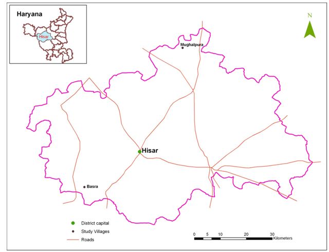
Location of the case study villages in Hisar District
The district of Etawah is located on the banks of the river Yamuna and is a confluence site for the Chambal and Yamuna, the two tributaries of the Ganga River. The western boundary of the district falls under the Chambal valley, a ravine zone shared with the adjoining state of Madhya Pradesh. Three villages were selected: Chandanpur, Dadra and Pachdeoara. Pachdeoara and Chandanpur are located in Badhpura Block of Etawah Tehsil in the northwest part of the district, a fertile loamy canal fed zone. Dadra is located in Chakarnagar Block and Tehsil on the southwest part of district, a partly ravine-partly loamy area.
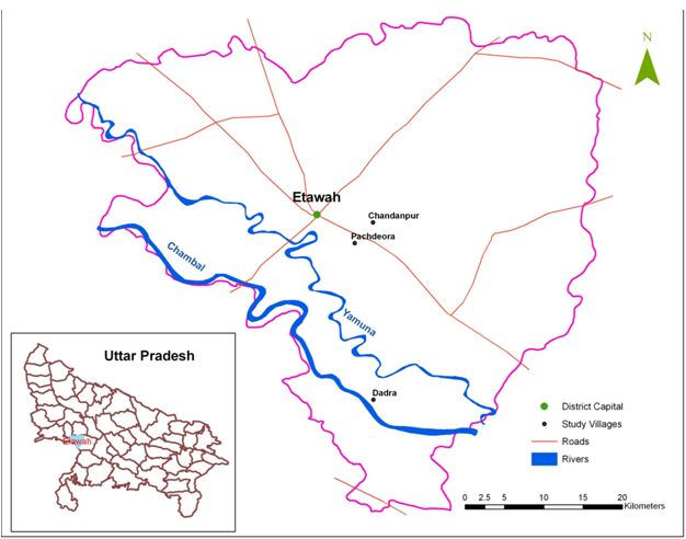
Location of the case study villages in Etawah District
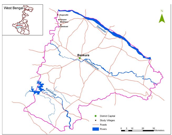
Location of the case study villages in Bankura District